Showing posts with label climate change. Show all posts

Tuesday, December 5, 2023

The city will pay you to participate in workshops to control rain

  https://www.wallpaperup.com/uploads/wallpapers/2015/11/19/838999/e1ce6c78dd41c13d66997838591ee1e2.jpg

Dear Community Leader,
Our city has endured tremendous hardships with the onset of more frequent and intense rainfall
events. In the face of this challenge comes an extraordinary opportunity to rethink its physical
and social infrastructure to reduce the risk from heavy rain while creating benefits for New
Yorkers every day.
 

The Mayor's Office of Climate & Environmental Justice and the NYC Department of
Environmental Protection, with Rebuild by Design and One Architecture and Urbanism, are
launching an open call for individuals and organizations who have lived or professional
expertise to recommend strategies and policies to address the increasing rainfall in New
York City. This work builds on an initiative launched by Rebuild by Design and One Architecture
to Rainproof NYC, as well as the City's efforts to improve flood resilience, including strategies
outlined in “PlaNYC: Getting Sustainability Done.”


Apply here by December 11 to express interest in joining a working group.
 

The Rainproof NYC working groups will have 15-20 members, split between NYC agency staff
and community leaders. The working groups will convene regularly from January 2024 to June
2024 and collaboratively propose new, or expand existing, policies, programs, and projects to
increase New York City’s resilience to heavy rainfall.


Each group will focus on the following topic areas. As part of the application, we ask that you
prioritize which group you would like to take part in:


● WORKING GROUP 1: How can we shift NYC’s policies and priorities to create a
comprehensive plan to prepare for increasing rainfall? Address gaps in infrastructure
and risk management to protect from and prepare New Yorkers for more intense
precipitation.


● WORKING GROUP 2: What does an equitable buyout program look like for NYC?
Inform the development of the City's Housing Mobility & Land Acquisition Program
announced in “PlaNYC: Getting Sustainability Done.”


● WORKING GROUP 3: How can we build capacity among communities, the private
sector, and CBO's to share responsibility to address increased heavy rainfall? Every
drop counts. Build out an education and communications campaign to build the
capacities of communities, the private sector, CBO's, local nonprofits, and other
agencies to do their part in managing increasing heavy rainfall.
We strive for diversity in the composition of each group across lived and professional expertise
and across intersectional identities. If you know someone who will bring new and unique
perspectives to these topics, please encourage them to apply too.

If selected, Rebuild will provide non-government members a stipend of $1500 at the end
of the process to support your high-level commitment. For those who cannot commit but
may want to stay involved, there will be various other opportunities to participate in working
towards a Rainproof NYC. We will continue to keep you apprised of those opportunities, even if
you choose not to apply to participate in a working group.


If you believe you have the expertise and availability to participate in a working group,
please APPLY HERE by noon on December 11, 2023. If you are accepted, you will be
invited to an afternoon half-day kickoff meeting that will be held on January 9, 2023 (please
hold your calendar for that date). Selected working group participants will be notified on or
around December 19.

 If you have any questions, email Rifal Imam at rimam@rebuildbydesign.org.
 

Sincerely,
The Rainproof NYC Steering Committee:
Rebuild by Design
The NYC Mayor’s Office of Climate & Environmental Justice
NYC Department of Environmental Protection
The NYC Mayor’s Office of Housing Recovery Operations
One Architecture and Urbanism

Mayor Adams took his 5% austerity machete to cut budgets from schools, libraries and the FDNY for these workshops to pay people to be make believe city planners to "mitigate" water coming from the sky. Workshops are the biggest farces going on in this town.

Sunday, July 16, 2023

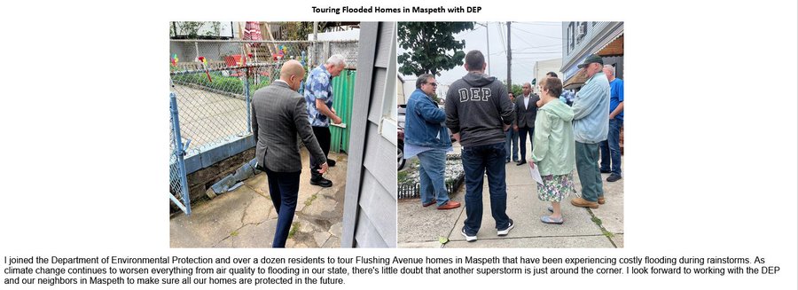
Juan Ardila brought climate change to Maspeth last week

 Image


I joined the Department of Environmental Protection and over a dozen residents to tour Flushing Avenue homes in Maspeth that have been experiencing costly flooding during rainstorms. 


The picture on the right was taken this past winter and not recent. Look at the snow on the lawn.


Wednesday, August 17, 2022

NYC Comptroller to Hurricane Ida flood victim homeowners: drop dead


PIX 11 News 

 New York City’s comptroller’s office shot down the thousands of people who filed financial claims against the city in the wake of Hurricane Ida.

Historic flooding from the drenching downpours destroyed the homes of many in 2021. In the aftermath, 4,703 people filed complaints with the city because of the flooding, as first reported by THE CITY. Each complaint was denied, a spokesperson for Comptroller Brad Lander’s office said. Letters went out to New Yorkers explaining that New York is not legally responsible.

“For over a century, courts have held that municipalities across the state of New York, including the City of New York, are not liable for damage from ‘extraordinary and excessive rainfalls,'” Lander wrote to New Yorkers in the denial letter. “Where damage is caused by negligent action or omission on the part of the City of New York, the City may be liable; however, that was not the case here.”

Ida dumped as many as 9 inches of rain in parts of New York City on the night of Sept. 1, 2021, according to the Department of Environmental Protection. In just one hour, 3.15 inches of rain fell in Central Park, breaking a record.

“As a result, the City of New York is not responsible for losses arising from Hurricane Ida, and your claim must be denied,” Lander wrote.

New Yorkers whose claims were denied can sue the city at any point within 1 year and 90 days of Ida, according to his office. That gives people until late November of 2022.

THE CITY 

Nearly a year after the remnants of Hurricane Ida flooded the Forest Hills one-bedroom apartment where Heidi Pashkow and her husband live, the couple is finally beginning to settle back into their first-floor home of over four decades. That’s after living with their son’s family for about nine months and spending almost $30,000 on repairs, Pashkow said.

She received a couple thousand dollars from the Federal Emergency Management Agency (FEMA) and filed a negligence claim against the city for damage caused by sewer overflows in the storm, in the hopes of receiving some money.

Pashkow said she was “shocked” when she received a letter on Monday from City Comptroller Brad Lander completely denying her claim.

She wasn’t the only one: 4,703 New Yorkers filed claims against the city after their homes flooded during Ida. All 4,703 were denied, according to the comptroller’s office.

The crux of the claims is that the city’s negligence in sewer maintenance led to flooding damage.  

The storm killed at least 13 people in New York City on Sept. 1, 2021, as it dumped over three inches of rain in a single hour on Central Park, shattering previous rainfall records — and overwhelming the city’s sewer systems, which were built to handle rainfalls of under two inches an hour.

The comptroller’s office says it investigates each claim to determine whether city negligence led to the flooding. But the decisions rely on precedent set by a case from 1907 that ruled municipal governments are not liable for damage from “extraordinary and excessive rainfalls” — even if the city’s sewer system was under capacity.

“As a result, the City of New York is not responsible for losses arising from Hurricane Ida, and your claim must be denied,” read letters sent by the comptroller and obtained by THE CITY.

Pashkow said she thinks the city is “absolutely” at fault because it oversees the infrastructure.

“I could challenge it and say, ‘Well, if you had your sewer fixed, it wouldn’t be a problem,” Pashkow said. ​​

“No one is moving back on the first floor, only me and the super,” she said in a separate text message Tuesday. “All are paranoid and so am I when it rains.”


Sunday, July 17, 2022

City Council approves Edgemere overdevelopment


City Limits
 

 The City Council voted Thursday to rezone a 166-acre swath of Edgemere, approving a plan first proposed by the de Blasio administration that could add more than 1,200 new housing units and improve resiliency in a Queens neighborhood at severe risk of flooding.

The land use plan, part of a broader initiative known as Resilient Edgemere, encompasses the area bound by Beach 35th Street and Beach 50th Street and will change zoning rules to increase density in some areas, limit development in others and raise the shoreline along Jamaica Bay. Resilient Edgemere also includes efforts to develop housing on city-owned parcels, elevate homes, improve parks and infrastructure and designate 16 acres as open space to be used for coastal protection.

The Council specifically approved five applications submitted by the city’s Department of Housing and Preservation and Development (HPD) to amend the zoning and allow for new development with mandatory inclusionary housing (MIH) affordability rules, which force developers to cap rents on a portion of their units for low- and middle-income New Yorkers. Around 530 new units will be affordable under MIH, according to HPD, and 35 percent of those affordable units will be up for sale, not rent. The plan would further a Community Land Trust on up to eight acres of city-owned land.

Resilient Edgemere establishes two special coastal risk districts, which HPD defines as “currently at exceptional risk from flooding and may face greater risk in the future.”

Councilmember Selvena Brooks-Powers, who represents Edgemere and other neighborhoods in the eastern portion of the Rockaway Peninsula, said the changes will allow for more affordable homes in the waterfront neighborhood, while shoring up the region against rising sea levels and storm-related flooding.

“Edgemere will benefit from vital affordable homeownership opportunities, infrastructure investments and protection from a changing climate,” Brooks-Powers said. “Rockaway has seen a surge of new development in recent years, but that development has not been accompanied by a commensurate investment in local infrastructure.”

Brooks-Powers inherited the project from her predecessor, Donovan Richards, who was elected Queens borough president in 2020 and told City Limits he was pleased that the Council voted to approve the rezoning after seven years of planning and community engagement. Richards recommended the plan in his advisory role in March but urged the city to foster affordable home ownership opportunities in response to community demands.

“There is tremendous promise in the Resilient Edgemere Community Plan,” Richards said, adding that he would focus on ensuring that developers and the city adhere to local hiring and MWBE commitments.

Under the changes, which now await Mayor Eric Adams’ signature, most of the area north of Beach Channel Drive would be zoned for one- and two-family homes, while the stretch between Rockaway Beach Boulevard and Edgemere Avenue would allow for taller, mixed-used buildings. City-owned vacant land next to the Edgemere Houses would be converted to open space, as would much of the land abutting the Jamaica Bay.

In a statement following the vote, Adams hailed the plan as “an important step forward for residents of Edgemere, the Rockaways, and the entire city.”

Wednesday, April 6, 2022

Down in the hole

 https://cdn.vox-cdn.com/thumbor/7fmz0bveR1V06E8K3rPPGska7-Y=/0x0:3000x2000/920x613/filters:focal(1260x760:1740x1240):format(webp)/cdn.vox-cdn.com/uploads/chorus_image/image/70710307/032722_the_hole_3.0.jpg

 THE CITY

Clement Bailey didn’t know what to expect when he moved from Flatbush just as the city shut down in March 2020

He’d bought a two-family house in The Hole, a low-lying neighborhood wedged between South Conduit Avenue and Linden Boulevard that straddles the border lines of East New York, Brooklyn, and Lindenwood, Queens.

Some call it the “Jewel Streets” neighborhood, for thoroughfares with sparkling names like Sapphire, Emerald, Amber and Ruby. But the area sits below the city’s municipal sewer network. With swampy flooding, septic seepage and illegal dumping, the atmosphere is lackluster.

“I can’t stand these conditions, honestly. I’m not used to living like this,” said Bailey, 29. “Everything inside the house is pretty peaceful, but when you step outside the door, you have to deal with all the water issues, the garbage issues. It’s not really appealing.”

A construction worker, he bought the house for his mother and sister to live in. But his mother died last year, and so he’s been living there with his sister.

In The Hole, many homes aren’t serviced by the city’s sewers and instead use septic tanks, which tend to overflow when there’s rain. There are no stormwater drains, so Bailey and his neighbors often navigate lakes of standing water in the streets. Abandoned vehicles sit in empty lots. Paved roads are inconsistent. Strewn trash abounds.

And it’s been this way for decades.

Plans to address the issues have long been stuck in the muck: Twenty years ago, the Giuliani administration proposed elevating the streets and installing sewers in the area. The plan’s been included in the city’s capital budget for at least two decades. Yet nothing was ever done. The most recent “request for proposals” on the project went out in 2019, but remains on hold, according to the Department of Environmental Protection.

Sunday, April 3, 2022

Endangered Spaces

Snow geese share the landscape with the A train in Broad Channel. The mix of wild natural features and city infrastructure  makes the area distinctive.

New York Times 

Don Riepe pointed to the line on the wall five and a half feet above his kitchen floor. That was where floodwaters reached during Hurricane Sandy in 2012.

His home, a humble two-story wooden structure, is decorated with nautical maps, horseshoe crabs and assorted maritime paraphernalia. It sits right on Jamaica Bay, with a small dock at the water’s edge, where he moors his 22-foot boat. He has a spectacular view of the east end of the bay with the spires of Manhattan in the distance.

Mr. Riepe, a former manager of the Jamaica Bay Wildlife Refuge, considers himself blessed to be surrounded by nature and still have all the perks of a big city a subway ride away. But he knows his neighbors’ time there may be coming to an end. During his four decades living in the area, Hurricane Sandy was the worst Mr. Riepe has seen; the flooring and all the electrical appliances on the first floor of his house were destroyed. Since then, during lesser storms and even high tides, he moves his computer and furniture upstairs, where he sleeps — and he hopes for the best.

Mr. Riepe is just one of tens of thousands of residents who live on the wild fringes of Queens, in communities like Hamilton Beach, Edgemere and Howard Beach, where the ocean threatens to encroach as sea level rises and coastal storms intensify owing to climate change. It is also the focal point of a major environmental restoration project that aims to protect the area — and in fact the whole city — by returning salt marshes and sand dunes to their natural states. How this will affect the community of Broad Channel (the only inhabited island in Jamaica Bay) remains to be seen.

Already, Mr. Riepe’s neighbors are scrambling to adjust to their new climate-changed reality — moving their cars to higher ground on high-tide days, and in some cases converting their ground floors into garages and shifting their living quarters upstairs and out of harm’s way. One thing that they are not yet prepared to do, however, is move out.


Crains New York 

Flushing Meadows–Corona Park, one of the most frequently flooded green spaces in the city, is getting a comprehensive plan on how best to adapt Queens’ largest park to climate change.

This month a congressional spending bill green-lit a $530,322 grant for the Waterfront Alliance to lead a climate resilience plan for the 897-acre park. Those federal dollars, which Queens Rep. Grace Meng requested from Congress last year, will enable the alliance to develop a road map of infrastructure projects and priorities to stymie prolific park flooding, which is only expected to worsen with increasingly heavy rains and sea level rise.

After heavy rainfall, it’s common for huge puddles to transform park basketball courts and fields into ponds for days. Overflow from both Meadow and Willow lakes frequently engulfs trails, making the park a challenge to navigate. Hurricane Ida laid those challenges bare with torrential rains that flooded the park and overflowed onto the Van Wyck Expressway and Grand Central Parkway, which spurred emergency rescues for drivers trapped on the roads.

That’s nothing compared to what’s on the horizon. Without upgrades, much of the green space, which is a former tidal wetland, could be permanently inundated by 2080, the New York Panel on Climate Change said.

Karen Imas, vice president of programs at the Waterfront Alliance, said the city must ensure the park is “prepared for our climate future.” The best way to do that, she said, is by developing a plan with those who know the park best.

“This is really an opportunity to work hand in hand with the community in and around the park and with city agencies to identify what are the greatest hazards and vulnerabilities, and how they can be addressed,” Imas said. That will likely be through a mix of projects, including wetland restoration, bioswales and revamped sewage infrastructure, she added.


Saturday, January 15, 2022

Manhattan penis extension proposal

https://pbs.twimg.com/media/FJEuJCYXoAI8R6R?format=jpg&name=medium 

New York Times

On Jan. 1, Eric Adams was sworn in as New York’s 110th mayor. He is now in charge of the city’s response to big, and growing, problems. One is a housing affordability crisis. Another concerns the ravages of climate change: sea level rise, flooding and storm surges.

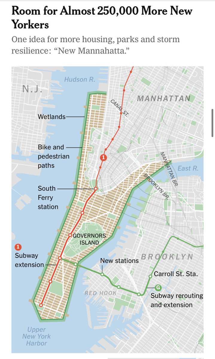
There is a way to help tackle both issues in one bold policy stroke: expand Manhattan Island into the harbor.

Last September, after witnessing unprecedented flooding from the remnants of Hurricane Ida, Mr. Adams said that it was “a real wake-up call to all of us how we must understand how this climate change is impacting us.” This realization should spur him to pursue aggressive measures to mitigate climate change’s devastation.

Both Mayors Bill de Blasio and Michael Bloomberg offered climate-change plans that included extending the shoreline along the East River in Lower Manhattan. But these proposals, while admirable, would be small steps and would hardly make a dent with problems of such big scale.

This new proposal offers significant protection against surges while also creating new housing. To do this, it extends Manhattan into New York Harbor by 1,760 acres. This landfill development, like many others in the city’s past, would reshape the southern Manhattan shoreline. We can call the created area New Mannahatta (drawn from the name the Lenape gave to Manhattan).

A neighborhood of that size is bigger than the Upper West Side (Community District 7), which is 1,220 acres. Imagine replicating from scratch a diverse neighborhood that contains housing in all shapes and sizes, from traditional brownstones to five-story apartment buildings to high-rise towers. If New Mannahatta is built with a density and style similar to the Upper West Side’s, it could have nearly 180,000 new housing units.

Opinion Conversation The climate, and the world, are changing. What challenges will the future bring, and how should we respond to them?


Saturday, December 11, 2021

Shitty Frank Lloyd Crap eco-rowhouse for sale


NY Post

It’s been called “The ugliest building in Queens,” and once won a “Frank Lloyd Crap” award.

Now, the “Climate Change Row House” — aka the Lego House — is on the market for $3.6 million.

The 3,487-square-foot property, at 45-12 11th St. in Long Island City, Queens, was originally built in 1903, and rebuilt in 2014 by its owner, architect Thomas Paino, to passive-house standards.

The 3-year renovation elevated the home’s basement out of the floodplain and made it more environmentally friendly.

But it was a new multicolor tile façade that got real estate watchers talking.

The home also includes a rooftop solarium, triple-pane windows for temperature and sound insulation and a hospital-grade air filtration system — a nice selling point during a pandemic. 

 Rupert Murdoch's gazette neglected to credit this blog for the Frank Lloyd Crap designation.


Friday, November 5, 2021

Rockaway's long belated and selective resiliency concern

Impunity City 

 Climate change was somewhat kind to New York City this year compared to the devastation that continues to happen in other states and nations with tropical storms, hurricanes and tornadoes and the apocalyptic hell fires that are happening frequently in California;  although with the exception of the remnants of Hurricanes Henri and Ida causing record amounts of water vomiting from the sky which led to destruction and sad deaths of the city’s lower income citizens here. Mostly because of the record heat NYC has received this year, with the hottest July on record, this mild weather has also led to what will sure to be the warmest October in this city in 2021, which comes to mind the last time summer stuck around for another month in 2012 when the pleasant weather gave way to the kraken that was Hurricane Sandy a few days before Halloween.

 Sandy laid destruction and death of her own in a 24 hours across the coastal towns and areas and updated flood zones of the five boroughs, notably in Rockaway Beach where she destroyed the entire boardwalk 9 years ago. But with funding from FEMA,  it took a few years to build another boardwalk, this time with rebar and concrete to replace all the wood that was reduced to kindle and also billions of pounds of sand for dunes. This led to longer treks to find some real estate to lay your towels and coolers down on the beach, but at least it provided protection from the hostile waters of the Atlantic that has been rising and eroding the shores of the peninsula for years before that bitch Sandy arrived.

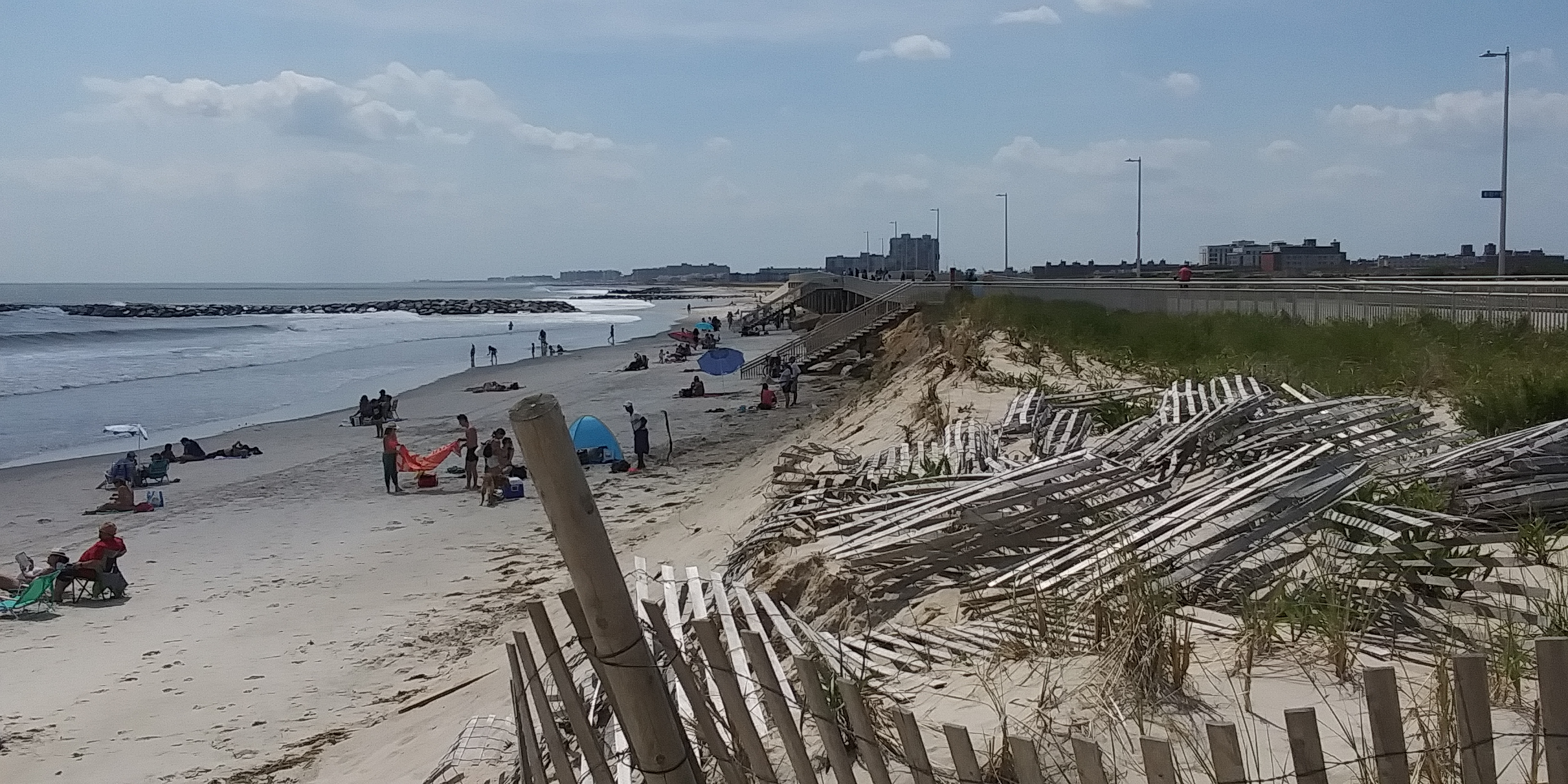
 And nigh a decade later, Rockaway Beach’s shore is in dire straits again. Most evident on the most conveniently accessed and popular beach area at Beach 98 st., the boardwalk entrance ramp to the sand is more fit for kayaking than a path for sunbathing.


Thursday, July 1, 2021

This is not a wetland: demonstration at Cuomo's office announced


The cutting down of the trees has begun. We are no longer asking for help. We are now demanding a stop to this insanity! In this age of climate change and sea level rise, torrential rain storms and storm surges, and with the city talking about resilience for shore line communities, why are they destroying the only resilience this black, brown (60% to 70%), elderly, disabled and low income community has? When Granitevillle loses its forested wetland, we will not only be at high risk of flooding and asthma, COPD and other illnesses from toxic air and water pollution but this loss will also create a heat

island effect, which means higher temperatures in this community than before the forest was cut down. I just now received an alert on my cell phone to reduce energy use or we will have energy disruptions.  This is the new normal. This is also madness!

CWF will demonstrate in front of Governor Cuomo's office in Manhattan. Join us! Here are the details:

Date: Wednesday, July 7, 2021

Time: Gather at 4:30 pm. Demonstration begins at 5pm

Location: 633 3rd Ave, Manhattan, between 40th St and 41st St

Bring signs and banners

Bring family, friends and your organizations and join us in demanding justice for these vulnerable communities. Stop the destruction of the Graniteville forested wetland.

Links to photos:  (What is as of now)

and


Monday, April 12, 2021

City and state officials have had it with the Rockaway pipeline


Queens Eagle

Over two dozen New York City leaders have urged the federal government to kill a controversial pipeline project that would run underneath the waters off the Rockaway Peninsula. 

The proposed Williams Northeast Supply Enhance Pipeline, or Williams Pipeline, would deliver fracked gas from Pennsylvania to New York city via a tube underneath New York Harbor. The plan was rejected last year by New York’s Department of Environmental Conservation. 

In a letter Wednesday, Comptroller Scott Stringer, Queens Borough President Donovan Richards and State Sens. Joseph P. Addabbo, Jr., Jessica Ramos and James Sanders called on Federal Energy Regulatory Commission Richard Glick to also reject the Williams Pipeline once and for all. The pipeline would move the city and state further from achieving its climate goals, they said.
“We take climate change seriously, as we have already lost loved ones here in New York City to climate-fueled superstorms and heat waves that caused death, illness, debt, and scarcity,” the leaders wrote. “For our constituents and for the future generations who will live with the consequences of allowing the Williams Pipeline to be built, we urge you to deny Williams’ request.”

The letter cites Glick’s own condemnation of the initial FERC approval of the project in 2019, when he said that declaring the pipeline safe “fails to give climate change the serious consideration it deserves and that the law demands.”

On March 19, Transcontinental Gas Pipe Line Company requested a two year extension to kickstart the project. The 17.4-mile-long, 26-inch diameter connection would transport fracked gas under the Atlantic Ocean off the shores of Rockaway Beach.

The letter cites the emissions impact of the gas being brought into the city once burned, new FERC recommendations that take into account the effects of transporting the gas  — like methane leaks — and climate justice for the city’s most vulnerable communities.

“We will not allow the racist legacy of environmental and climate injustice to continue by building infrastructure that will increase the amount of polluting fracked gas in our city,” the letter continues


Friday, December 4, 2020

The tide is nigh for endangered affordable housing

https://images.squarespace-cdn.com/content/v1/5b9ffe0f1137a680c2c08250/1607017928204-LT0VC11EQQUGH0321VIQ/ke17ZwdGBToddI8pDm48kPZoFzfdH-BtuMfavJKf2H9Zw-zPPgdn4jUwVcJE1ZvWQUxwkmyExglNqGp0IvTJZamWLI2zvYWH8K3-s_4yszcp2ryTI0HqTOaaUohrI8PI6uq3lIRrTFlZLAXXG0jAbzUCoswZ2f3i4aYUGxdW5WAKMshLAGzx4R3EDFOm1kBS/flood.jpeg?format=750w


Queens Eagle 

Tenants in nearly 1,800 subsidized housing units in Queens could be displaced as a result of rising sea levels over the next 30 years, according to the first nationwide analysis of the climate crisis’ impact on affordable housing. Nearly all of the impacted units are located in the eastern portion of the Rockaway Peninsula, including Far Rockaway and Arverne.

The peer-reviewed study published by the organization IOPScience found that flooding will render more NYCHA, Section 8 and other subsidized homes unlivable in New York City than any other city in the country by 2050.  

Authors Maya Buchanan, Scott Kulp, Lara Cushing, Rachel Morello-Frosch, Todd Nedwick and Benjamin Strauss refer to these subsidized units as “affordable housing” as they consider the impact of rising sea levels on 20 vulnerable coastal cities including Boston and Miami Beach.

“The frequency of coastal floods around the United States has risen sharply over the last few decades, and rising seas point to further future acceleration,” they write. “Residents of low-lying affordable housing, who tend to be low-income persons living in old and poor quality structures, are especially vulnerable.“

An interactive map published alongside the report shows the specific communities facing the greatest risk, with nearly all the units concentrated in Far Rockaway and Arverne. The two neighborhoods have a high number of NYCHA and Section 8 units compared to other waterfront neighborhoods of Southeast Queens and the Rockaways.

A city plan to rezone coastal communities for greater resiliency highlights the dangerous impact on Broad Channel, Howard Beach and the neighborhoods around Flushing Bay, as well. All are expected to fall below the floodplain by 2050.
 

 The IOPScience report anticipates factors 30 years in the future, but New York City already has among the highest number of units vulnerable to flooding at least once a year, the authors write.

At least 1,373 subsidized units are vulnerable right now, a total that represents less than 1 percent of the city’s current affordable housing stock, according to the paper by Climate Central and the National Housing Trust. 

“Climate-change-driven sea level rise will continue to amplify coastal flooding in the coming decades,” the report states.. “As community resilience investments are made, complementary policies may be needed to protect against the displacement (and potential homelessness) of residents.”

Wednesday, November 25, 2020

Seal appeal


Queens Eagle

Seals and humans have flocked to the Rockaways over the past nine months, leading to a higher-than-usual number of run-ins between the two mammal species — and the occasional unlucky dog.  Local marine wildlife experts warn well intentioned beachgoers to keep their distance: Seals aren’t as cuddly as they seem.

Human-seal encounters in New York City have increased by 45 percent this year, according to the New York Marine Rescue Center. Melting ice up north is driving seals to the coasts of Queens and Staten Island, while a thirst for the outdoors during the pandemic continues to compel New Yorkers to the beach, said New York Marine Rescue Center Program Director Maxine Montello

“A lot of our seals were at normal beaches that would be less populated,” Montello said. “But because of COVID and everybody coming out here earlier in the year, we had patrons that maybe had never crossed with seals and were super interested in these animals.”

The 16 encounters so far reported to the New York Marine Rescue Center in 2020 are the highest total in a decade, she said. Seven of the cases involved people pulling seals into the water, removing them from the beach and offering them food and water, Montello said.

The center has also found that more seals are sticking around for the summer, which may result from trouble up north. According to the International Fund of Animal Welfare, melting ice in the Arctic has increasingly displaced Atlantic seal populations that rely on pack ice to birth and wean pups. 

Milder winters caused by climate change can spur unusual seal migration patterns, bringing more herds to New York’s shores. Rescue groups have encountered harp seals, an Arctic species among the first to migrate to New York Harbor each year, hauling themselves further up on the beaches in search of ice.

Harp seals started showing up in the area around the mid-1980s, said Marine Mammal Stranding Center Director Bob Schoelkopf. Since then, the harp seal population has been on the rise in the Tristate Area. New Jersey had its first recorded harp seal birth several years ago.

Friday, October 30, 2020

Here come the warm jetties


Gothamist

Construction on six-miles of storm surge flood protection along the Queens waterfront began on Thursday. The work is starting eight years after Hurricane Sandy battered waterfront communities in the Rockaways and across New York City.

"It's a really, really exciting milestone to now see this work move forward, especially for a community that was so devastated by Hurricane Sandy," Jainey Bavishi, the director of the Mayor's Office of Resiliency told Gothamist. "We're now working to transform the waterfront, and build climate protection into it. And this is just one of many examples that we'll see come online."

The Rockaways were hit hard by the 2012 storm. More than 1,000 structures were destroyed, and 10 feet of storm surge flooded the area. Queens residents lived for months without heat and with mold in their homes from the water damage.

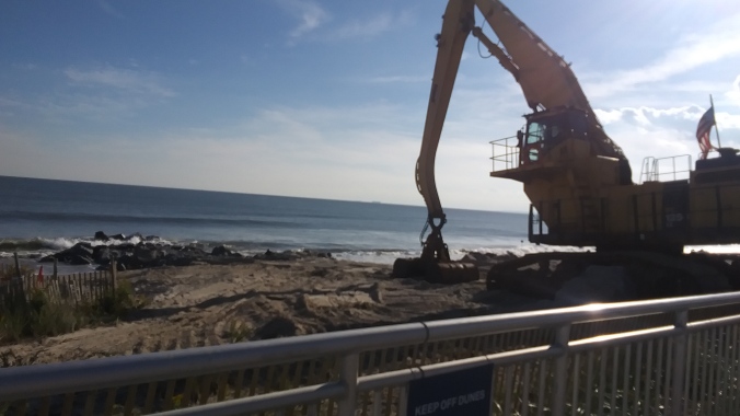
The first phase of the Rockaways — Atlantic Shorefront project includes building out or restoring nearly 20 stone groin structures—similar to rock jetties—into the ocean to keep sand from washing away on the beach.

Then, a network of dunes built after the 2012 storm will be reinforced with stone and steel to make them two-to-four feet higher. Then more sand will be added to the beach.

"All these elements will provide various layers of protection for the Rockaway peninsula," Bavishi said.

The federally-funded, $336 million project, runs from Far Rockaway to Riis Beach, and is supposed to be completed in 2024.

Thursday, March 14, 2019

Mayor de Blasio wants 10 billion dollars to save Downtown Manhattan from climate change


NY Daily News


Mayor de Blasio proposed extending the South Street Seaport area by two city blocks into the East River — part of a $10 billion effort to fend off rising sea levels as a result of climate change.


“We had to find something that would work, no matter how expensive or ambitious it was,” de Blasio said Thursday at a press conference downtown.


The plan, part of a resilience study released Thursday, calls for extending the shoreline by a maximum of 500 feet, or two city blocks. The new segment of the shoreline, which would be 20 feet or above current sea levels, would serve as a flood barrier during storms — but it could also be home to buildings, including potential private development, de Blasio acknowledged.


But it will be necessary to keep lower Manhattan from being underwater, he argued -- saying the city’s study had found that by 2100, 20% of the streets in area would experience daily tidal flooding, even in sunny weather.


“This is the existential threat. This is the core issue we all must face as aggressively as humanly possible,” de Blasio said.

 The plan, announced six years after Hurricane Sandy swamped the city, may sound familiar to some New Yorkers — in 2013, Mayor Bloomberg proposed a similar project dubbed “Seaport City.” That plan would have leveraged private development on the new land to pay for the massive expense of building it.


De Blasio said whether the new land would contain private developments depended on whether the federal government would pony up any cash for the plan.

 From the perspective of the City of New York alone, this would be extraordinarily difficult to fund. I think it comes down to simply this: if there’s federal money in play, it probably looks one way, if there’s not federal money in play, we have to get some private money and there has to be some development,” he said.


What happened to the affordable housing plan? What about emergency funding for NYCHA?

The mayor proves yet again where his priorities lie, with the real estate overlords. New development? If all those luxury towers around there are under threat now from accelerating sea level rise, why would you build more "private" development on the new shoreline
If there is a light side to this idiotic proposal, this ten billion dollar defense of luxury real estate from the effects of climate change seems to be inspired not only from de Blasio's obeisance to his biggest donors (obviously still) but from a mentally retarded female character from the classic comedy show Arrested Development.


Monday, February 25, 2019

Coastal erosion at Rockaway Beach has got menacingly worse


CBS New York

It’s not summer just yet, but one Queens community is fed up that nobody seems to be stepping-up to help in the year-round fight to save its beaches.

Residents say it’s been one broken promise after another to alleviate erosion on Rockaway Beach.
The Rodkin family were out for a winter walk along the concrete near the sand Friday afternoon. They’d have rather been strolling on the beach, but it’s been closed for months.
 
“Break’s my heart,” Alice Rodkin said. “My mom brought us here as kids. We can’t even enjoy our own beach.”
 
People who live nearby say the sand should be much higher than where it is, but rapid erosion means you’ll need to jump more than four feet to get from the boardwalk to the beach.

 Last spring, Cori said the erosion was “by far the worst” it had been. Fast forward to 2019, and the dunes are nearly half the size they were last April. He’s been fighting for the city and federal government to install barriers like jetties and rock groins to help protect the beaches as they’ve long promised they would.
 
“The Army Corps of Engineers said they’d be there in 2018 to tell us the plan,” Cori said. “Not even a word.”

 The federal agency says it’s working to make sure the area gets the most “effectively designed plan to reduce flood risk and combat erosion.” The city says its understanding is that should start late 2019.

This is a lot worse than what I saw last October in that same area.


 If only the city would heed it's own warnings from their lame art installation.


Update:

Here's a video of the ocean hitting the boardwalk entrance that reporter impressively jumped from.


Monday, March 12, 2018

LIC residents unhappy with City's plan

From the Times Ledger:

Hundreds of Long Island City residents and business owners rallied with community leaders and elected officials Saturday against the city’s plan to develop two plots of publicly owned waterfront property on 44th Drive and a neighboring Department of Education building on Vernon Boulevard.

The proposal, announced in 2016, would turn the city-owned lots into commercial space, luxury apartments and a school, but the community has other ideas that are not being heard by the de Blasio administration.

“With the critical lack of infrastructure in the area, from schools to transportation to senior centers, the fact that the city would try to sell precious public neighborhood land to private developers shows their shortsightedness and lack of understanding of the needs of the neighborho­od,” Hunters Point Civic Association President Brent O’Leary said. “I am proud of our neighborhood for standing up to the city and saying our neighborhood will not be sold off. If you want to develop community land, it is the community who should be deciding how that best helps the neighborhood not outside interests.”

The rally was organized by the group Coalition LIC whose online petition has over 1,000 signatures and would prefer the waterfront lots be turned into parkland with wetlands that would afford climate protection in a flood zone. The coalition wants the DOE building turned into a school with a community recreation center, artist and light manufacturing space, a cultural center, a climate change educational center and job training.

Tuesday, October 24, 2017

More frequent flooding for NYC

From PIX11:

Within the next three decades, floods that used to strike the New York City area only once every 500 years could occur every five years, according to a new scientific study released just days before the fifth anniversary of Superstorm Sandy.

The study, performed by researchers at several universities and published Monday in the Proceedings of the National Academy of Sciences, primarily blames the predicted change on sea-level rise caused by global warming.

“This is kind of a warning,” said Andra Garner, a Rutgers University scientist and study co-author. “How are we going to protect our coastal infrastructure?”

The researchers based their analysis on multiple models that factored in predictions for sea level rise and possible changes in the path of future hurricanes.

Friday, October 13, 2017

The chronic flooding of Hamilton Beach

Great photo essay at Curbed:

If you’d like to get a good picture of New York City’s struggle against sea level rise, head to Hamilton Beach and stand in the middle of the road.

Every month during the highest tides, the streets of this small Queens community are flooded by the waters of Jamaica Bay. At first, as the saltwater starts to trickle in from Hawtree Creek, the small puddles forming around curbs and storm drains don’t appear to be so bad. But as the tide continues to rise, the roads are quickly submerged.

Soon, tiny fish begin to swim across the concrete, and the water is above your ankles. Then swans start to paddle into empty lots, and the water has reached your calves. Suddenly, the flooding is knee high, and the nearest dry land is much too far away. It is a deeply disconcerting feeling, to be standing in seawater in the middle of a neighborhood.

Yet for those living in Hamilton Beach, and in many other neighborhoods around the city, street floods like this are a regular, everyday occurrence. “This is nothing,” says Ginny Dunker, looking out from her front door at a recent six-and-a-half-foot high tide that had flooded midway up her block. “Come back on a rainy day, and then you will see something.”

Hamilton Beach is just one of several New York City communities that are regularly flooded by high tides. Many of these neighborhoods are clustered around Jamaica Bay, including nearby Broad Channel and Howard Beach, and in each of these areas, saltwater has come up into the streets every month for decades. In recent years, however, residents have reported a dramatic increase in the frequency and volume of these floods.