
Showing posts with label waterfront. Show all posts
Showing posts with label waterfront. Show all posts
Friday, November 9, 2018
Amazon & Google may expand here
There are a bunch of articles out there about the possibility of Amazon and Google expanding here, so here are some of them for your perusal.
What Amazon May Mean for Queens: Gentrification and (More) Packed Trains
Local politicians grow concerned as Amazon HQ2 eyes Queens' Waterfront Plaxall property
Any zoning changes for Long Island City would hinge on local lawmaker
Bezos Turns Gritty Queens Area Glutted With Development Into 'Field Of Dreams'
Report: Google planning big New York City expansion


Friday, July 13, 2018
Barriers proposed for NY Harbor
From WNYC:
In a series of public information sessions this week, the Army Corps is presenting five options for protecting the area's waterfront, four of which involve storm surge barriers:
- a five-mile long barrier at the southernmost border of the lower bay, between Sandy Hook, N.J., and Breezy Point in the Rockaways;
- a smaller barrier between Staten Island and Brooklyn, across the channel that the Verrazzano-Narrows bridge spans, accompanied by gates across the mouth to Jamaica Bay and Arthur Kill;
- a series of berms and sea walls along low-lying portions of the New Jersey and New York City waterfront, along with small gates across some waterways;
- and an option that would only use berms and sea walls.
Monday, June 5, 2017
Sea level rise response in Staten Island vs Queens

We live in a strange moment, when on the one hand, the state government is paying millions of dollars to help hundreds of residents move away from the water in an orderly fashion, but on the other hand, the city and private developers are encouraging thousands of new residents to move into rapidly constructed waterfront towers that cost billions of dollars. These diametrically opposed plans for the waterfront are creating very different versions of the future, even as the city has begun to initiate its own managed retreat programs in Edgemere and beyond.
Friday, May 13, 2016
Tool created by city to help develop the waterfront

Applicants for construction permits on waterfront property can end up waist-deep in bureaucracy, but a new website will help them navigate.
The Waterfront Navigator website, funded by the Empire State Development Corp. and the city, aims to be a one-stop shop for users to figure out which permits they need from which agencies, and how to get them.
The city, state and federal government all have jurisdiction over the coastline and local landowners sometimes need sign-off on environmental compliance from all three levels of government before beginning normal city buildings permit processes.
"New York City has long been a global maritime hub for waterfront business owners and development, yet it has been a perennial challenge to navigate the complicated waterfront permit application process," said Maria Torres-Springer, president of the city's Economic Development Corp., in a statement. "This is largely because of the multiple layers of federal, state, and local entities with jurisdictional responsibility for waterfront construction permitting.”
More development. Less public access. NOW.
Thursday, February 25, 2016
City wants huge LIC parcel developed

In an effort to spark development along the Queens waterfront, New York City is looking for a developers to build up to 1.2 million square feet of offices, manufacturing space and apartments in Long Island City.
On Thursday morning, the de Blasio administration’s economic development arm will put out to bid two city-owned sites across the inlet from Gantry Plaza State Park.
Right now, they are occupied by a restaurant whose lease expires in 2017 and may or may not be included in the developer's plans, what the request for proposals describes as a "parking lot abutting lands underwater and a dilapidated over-water platform" and a one-story Department of Transportation building that might have to be relocated as part of any project.
The land would also likely have to be rezoned for uses other than manufacturing.
Why do we need to "spark" development along the Queens waterfront? Have they taken a look at what's there now? Why not just put it on the open market?
Wednesday, September 16, 2015
Costa wants more waterfront projects

Western Queens officials and community members are dreaming of an evening walk along the waterfront from Astoria Park to Socrates Sculpture Park.
City Councilman Costa Constantinides (D-Astoria) touted a plan to revitalize the shoreline Saturday during a festival held in conjunction with the Waterfront Alliance at Hallets Cove playground that would use allocated funding for projects along Astoria Hallets Peninsula.
“We’re a waterfront community, and we have very limited interaction with our waterfront,” Constantinides told reporters Saturday. “We’re really looking forward to reconnecting with our past, reconnecting with who we are as a community.”
The plan would include adding a new eco-dock, a floating dock that allows for various vessels to pull up to it, similar to the one already in Bay Ridge. The dock could include a kayak launch and would provide an educational opportunity on the local ecosystem. The proposal would also allow for an upgrade to Hallets Cove playground. He said adding Citi Bike to the area is also on the wish list.
Constantinides said he and Borough President Melinda Katz each allocated $1 million in this year’s budget, fiscal year 2016, for the projects, so that $2 million is “already secure,” he said. The Hallets Cove playground renovation has an additional $1.2 million allocated, $1 million from Katz and $210,000 from the councilman’s discretionary budget.
We know what this is really about.
Friday, August 15, 2014
Another factory to become residential

The latest launching pad for big-scale residential development in Astoria, Queens, has hit the market with an asking price of $60 million. The development site, located at 11-12 30th Drive, a parcel that stretches from the Astoria waterfront along Vernon Boulevard inland to 12th Street, can accommodate up to 460,000 square feet of residential space according to sources. Height limitations permit a building up to 10-stories tall.
In the late 1990s, a storage yard at a plastics factory on the site was gutted by a massive fire.
The parcel is currently home to a single-story factory building occupied by Bohea Associates, a grocery wholesaler. Adam Spies and Doug Harmon, brokers at Eastdil Secured, are handling the sale of the property on behalf of owner Vernon Realty Associates.
Thursday, January 16, 2014
This week's overdevelopment news
 From The Real Deal:
Boris Aronov, co-developer of Tribeca’s 101 Leonard Street, has paid $26.5 million for a development site on the Astoria waterfront, according to city records filed Friday. The 160,000-square-foot lot at 3-15 26th Avenue was marketed last year for $80 million as being ripe for an 800,000-square-foot residential site, but it’s currently still zoned for manufacturing, and sources said that the low purchase price was due to uncertainty about when the site would be ready for a residential project.
The seller was Le Noble Lumber Company, according to public records, which purchased the site in 1984. Avison Young’s Jon Epstein, who represented Le Noble along with colleague Arthur Mirante, attributed the large gulf between the asking and selling price to the fact that Le Noble decide to sell the site “as-is,” rather than securing a zoning variance. This means Aronov will now have to handle that costly and time-consuming process if he wants to build apartments.
From the NY Times:
Although Queens Plaza has succeeded in luring residential and hotel projects, it has been slower to attract new office buildings. Turning Long Island City into a central business district to rival Jersey City was a Bloomberg administration goal, but brokers who specialize in commercial real estate say that a significant influx of office tenants is still years away. “It’s been more of a trickle than a flood,” said John Reinertsen, a senior vice president at the brokerage firm CBRE, who is based in Long Island City.
From Brownstoner Queens:
Another hotel for Long Island City? Can’t say we’re shocked. The Department of Buildings issued a new building permit in December for a ten-story, 74-room hotel. The location in question, 40-47 22nd Street, is right on the corner of 44th Avenue and 22nd Street. According to signs on the construction fence, the ETA is for the summer of 2015.
Great, this is just what Queens needs!
Wait, where is the requisite "Long Island City is the next big thing!" article?
Here you go.
Wednesday, April 17, 2013
Hurry and develop more of Arverne before the next storm!

From Curbed:
Several competitions and exhibitions have cropped up focused on rebuilding and sustainable design in the wake of Hurricane Sandy. The latest, unveiled at the Center for Architecture today, came together in less than two months and involves a long-stalled site in a "distressed and somewhat ignored" area, in the developer's words, of the Rockaway Peninsula. The more-than-80-acre site in question, Arverne East, was designated for development by L & M Development Partners, Triangle Equities, and the Bluestone Organization seven years ago, but the financial crisis brought the plans grinding to a halt. Following the storm, the developers are ready to resume work, but the old site plan no longer applies. Instead, the developers (and a bunch of other partners listed on the competition site) are seeking input from architects, engineers, interested members of the community, and pretty much anyone else in a two phase competition. The full details and competition brief are available on the official website.
Regardless of who wins, the ultimate site plan will need to be mixed-use, sustainable, "storm-resilient," and mixed-income.
You really gotta love it when the mayor is encouraging more coastal development at the same time that the governor is paying people to leave the waterfront.
It's also interesting when the Curbed comments read like Queens Crap comments.
Wednesday, March 6, 2013
City breaks ground on waterfront development
 From Crains:
The Bloomberg administration broke ground Monday on the first phase of a huge residential project on the Queens waterfront that is destined to become the largest such development since Co-op City was built in the Bronx over forty years ago.
First to rise in Hunter's Point South section of Long Island City will be a pair of 30-plus story apartment towers, with 925 units. Before sinking his ceremonial shovel to the soil the mouth of Newtown Creek, Mayor Michael Bloomberg announced that two more towers will follow. The administration is poised to kick off the second phase of the project next month, when the city seeks a developer for another 1,000 units.
Monday's ceremony is another indication that the mayor is not shirking away from the waterfront in the wake of Superstorm Sandy.
So we're subsidizing waterfront development in an area that was underwater during the hurricane. That's really smart. 27 inch sea level rise by 2050...
Tuesday, March 5, 2013
Coming soon: skyscrapers with holes in them
 From the NY Observer:
When Two Trees Management bought the old Domino Sugar site from CPC Resources and a reluctant Katan Group, a local developer told The Observer that Jed Walentas would be “crazy to go back to ULURP” for a rezoning of the site, which had already been approved for thousands of high-rise apartments.
But going back to to everyone’s favorite acronym (to pronounce, at least) is exactly what Mr. Walentas intends to do. He and SHoP, the New York-based architecture firm that Bruce Ratner tapped to design the Barclays Center and Atlantic Yards after Frank Gehry proved too expensive, called a group of reporters to SHoP’s offices near City Hall on Friday to show off their plans for the site.
The first thing Mr. Walentas spoke about was Two Trees’ desire to expand the amount of parkland included in the project—adding two new acres—and to make it more accessible to the public.
He criticized the open space in the old site plan as something that “felt very much like a privatized front lawn for people who lived there,” and spoke about his desire to pull the buildings back inland to make more space for the quarter-mile-long waterfront park, as well as add a new public street between his buildings and the waterfront.
But the extra park space comes at a price: the towers will have to rise higher to make up for the smaller footprints. The tallest tower on the site would rise to 598 feet, or about 60 stories—much taller than the 340-foot maximum height in the currently approved plan.
Saturday, March 2, 2013
Poorly planned bike lanes installed at Astoria Park
 From DNA Info:
Parks advocates say the new bike lanes that the city installed in Astoria Park are too narrow and will be ripe for collisions between cyclists and pedestrians once the weather gets warm and the park is crowded with visitors.
They also say that the placement of the lanes on grass inside the park, instead of next to the waterfront on Shore Boulevard, will invite pedstrians to stroll on them, creating a dangerous situation.
"It's just too narrow — it doesn't seem to be big enough for pedestrians and bikes," said Martha Lopez-Gilpin, co-chair of the local group Astoria Park Alliance.
She said the group was originally thrilled with the idea of bike lanes being installed in the park, part of the city's Queens East River and North Shore Greenway, a $3.46 million urban trail project to connect the Queens waterfront.
But they were surprised this fall with the Parks Department's placement of the 4-foot wide lanes on park land, contrary to earlier dicussions that hinted they would be on the other side.
"It's where a greenway belongs — it belongs on the road," said Jules Corkery, the Alliance's other co-chair.
"By putting a bike-way into the park, you’re inviting bikes into the parkland," she said, saying it will inevitably lead to standoffs between cyclists and strolling pedestrians, or even between two bikes.
"You cant leisurely ride with a friend in the bike lane, side by side, the way you would in a park. It's too narrow," she said.
A spokesman for the Parks Department said the new bike lanes are intended for cyclists only, and that pedestrian lanes were added to the parts of the path that bordered the park's pedestrian walkways.
The bike-only lanes have been stenciled with a bicycle symbol to let pedestrians know to stay off, the spokesman said.
But Lucille Hartmann of Community Board 1 said that even with the markers, it's likely the lanes will be used by pedestrians making their way from inside the park to the waterfront.
"You're going to have people walking with carriages. They're not planned well," she said. "It doesn’t look like it's going to be safe for the bikers or for the pedestrians."
Tuesday, February 5, 2013
State plan to buy up storm-ravaged homes
From the NY Times:
Gov. Andrew M. Cuomo is proposing to spend as much as $400 million to purchase homes wrecked by Hurricane Sandy, have them demolished and then preserve the flood-prone land permanently, as undeveloped coastline.
The foundation is all that remains of 45 Kissam Avenue on Staten Island. Many homes were totaled during the storm and work crews have been demolishing what is left.
The purchase program, which still requires approval from federal officials, would be among the most ambitious ever undertaken, not only in scale but also in how Mr. Cuomo would be using the money to begin reshaping coastal land use. Residents living in flood plains with homes that were significantly damaged would be offered the pre-storm value of their houses to relocate; those in even more vulnerable areas would be offered a bonus to sell; and in a small number of highly flood-prone areas, the state would double the bonus if an entire block of homeowners agreed to leave.
The land would never be built on again. Some properties could be turned into dunes, wetlands or other natural buffers that would help protect coastal communities from ferocious storms; other parcels could be combined and turned into public parkland.’
The Federal Emergency Management Agency has financed the purchase of homes in disaster-stricken areas for two decades. Hundreds of property owners in upstate New York decided to pursue buyouts after Tropical Storms Irene and Lee, though no sales have been finalized, according to state emergency management officials.
Mr. Cuomo is proposing a far broader program for homeowners affected by Hurricane Sandy, using money from the federal Department of Housing and Urban Development, an agency Mr. Cuomo once headed.
The buyout program requires approval from the federal housing agency. The governor’s office said federal officials seemed receptive to their proposal, and that Mr. Cuomo hoped the program would be approved and that he could announce details in the next two weeks.
A spokesman for the Hurricane Sandy Rebuilding Task Force, which President Obama created in December, said Sunday that it is too soon to say whether the state will be allowed to proceed.
Monday, January 7, 2013
No good deed goes unpunished

From the NY Times:
Once home to colonial estates and a Cuban sugar importer, then a public beach, a railroad float yard, a city landfill during the Bronx’s burning years, an illegal dumping ground tied to the mob, a proposed power plant and a jail, Oak Point, which Mr. Smith developed, now features a $60 million warehouse supplying food to bodegas and restaurants.
For three months the waterfront on the 28-acre site was also home to a wetland with verdant slopes and grassy marshes. Paradise in the Bronx.
And then it was all lost: two years of planning, nine months of work, $1.5 million and three acres of wetlands washed away in a matter of hours by Hurricane Sandy’s 13-foot storm surge. What remain are a few patches of marsh grass, a Charlie Brown-like evergreen and one lonely, weedy mound just below a concrete wall.
Based on what survived, Mr. Smith advocates rebuilding by integrating, or layering, hard and soft materials.
He has a wider vision, though, beyond the waterfront, for his remaining 13 acres. He plans a three-level “food campus” for a wholesale farmers’ market for New York State growers, a rooftop greenhouse, a kitchen incubator and public space overlooking the water. In December, Oak Point’s second phase (projected at $80 million) received a $400,000 economic development grant from Gov. Andrew M. Cuomo.
Sunday, December 9, 2012
Developer may create wetland in College Point

From the Times Ledger:
Developers looking to build a six-story condo complex on the shores of College Point are mulling over an agreement with environmentalists that would create wetlands in front of the property, an amenity that could prove useful if the city is slammed by another serious storm.
Waterfront Resorts Inc. is currently seeking the city’s permission to build a 134-unit condo complex that incorporates into the design the aging brick building once known as the Chilton Paint factory, where 15th Avenue meets the water. The owners have to jump through bureaucratic hoops to build the residential complex in a manufacturing district, but they are also considering honoring a contract that would create wetlands and an artificial oyster bed off shore.
“If it’s within our budget, we can do it,” said Benjamin Lam, project manager at Waterfront Resorts. “If it’s a considerable amount, I need to make sure that my books can handle it.”
The books for the project have been of constant concern for Lam and his company, since they have been trying to finance the project since 2008.
In fact, they purchased the property from another developer that year, just as the financial crisis made it exceedingly difficult to get investors to commit to capital spending for the development.
Many aspects of the project carried over, including the rough plans for how the building would look. But it was uncertain whether Lam and the company would honor the contract to build wetlands signed by the previous developer, Silvio Spallone.
Funding for the project is still far from complete and the permission sought from the city is merely an extension of an initial 2005 request. But should the project come to fruition, a College Point environmentalist contends that the wetlands would not only be a bonus for the environment, but could also make a modest contribution to protecting the city from weather events like Superstorm Sandy.
Sunday, December 2, 2012
End of the coastal lifestyle?

From the NY Times:
New York and New Jersey residents, just coming to grips with the enormous costs of repairing homes damaged or destroyed by Hurricane Sandy, will soon face another financial blow: soaring flood insurance rates and heightened standards for rebuilding that threaten to make seaside living, once and for all, a luxury only the wealthy can afford.
Homeowners in storm-damaged coastal areas who had flood insurance — and many more who did not, but will now be required to — will face premium increases of as much as 20 percent or 25 percent per year beginning in January, under legislation enacted in July to shore up the debt-ridden National Flood Insurance Program. The yearly increases will add hundreds, even thousands, of dollars to homeowners’ annual bills.
The higher premiums, coupled with expensive requirements for homes being rebuilt within newly mapped flood hazard zones, which will take into account the storm’s vast reach, pose a serious threat to middle-class and lower-income enclaves. In Queens, on Staten Island, on Long Island and at the Jersey Shore, many families have clung fast to a modest coastal lifestyle, often passing bungalows or small Victorian homes down through generations, even as development turned other places into playgrounds for the well-to-do.
While many homeowners are beginning to rebuild without any thought to future costs, the changes could propel a demographic shift along the Northeast Coast, even in places spared by the storm, according to federal officials, insurance industry executives and regional development experts. Ronald Schiffman, a former member of the New York City Planning Commission, said that barring intervention by Congress or the states, there would be “a massive displacement of low-income families from their historic communities.”
Monday, November 26, 2012
Yuppie worries about property values

From the Queens Courier:
Writing in the days after Sandy I simply could not avoid thinking how this event may affect real estate business for years to come. Although the condo building where I live was spared any damage (floor waters stopped 10 feet from our garage before they started to recede), the Murano on Borden Avenue was hit twice as hard — in addition to flood damage to their lobby, rec room, gym and garage, the city’s sewage lines back-flowed into their mechanical room, adding insult to injury (or smelly mess to water damage). Turns out Con Ed won’t work to restore your electricity until you make the area clean for them. They estimate from $100,000 to $250,000 in damages. Among the new buildings, the worst water damage occurred at the City Lights, Powerhouse and the Foundry buildings, where the flood waters reached as high as 5 feet above ground, including some private apartments. Amazingly, the piers and Gantry Park did not sustain too much damage, testament to how well they were designed and built. We cannot discount damages that businesses like Riverview and Crabhouse restaurants or Brighter Babies and LIC Kids facilities have sustained, not to mention all the small warehouses, offices and of course individual homes that got caught in Sandy’s surge, which reached as far east as half-way between 5th Street and Vernon Boulevard all the way up to Borden Avenue in the south, and 46th Drive and Vernon Boulevard in the north (where my own car was treated to 3 feet of water!)
It was refreshing to see resilient parents march their kids at the Halloween parade the day after the storm, and restaurants on Vernon packed with residents supporting local retailers as if they wanted to show how much they appreciated getting through it all relatively untouched. But overall damage a dozen of businesses in Hunters Point may actually put them close to the brink of closing doors, regardless of insurance coverage or defiant stance of its proprietors. In a small market like LIC, even a small hit, like low health department grade or destruction of locals’ favorite park next door can strain a retailer’s bottom line. Let’s hope that our local businesses recover quickly.
Instead of bold predictions, analysis or data, all of which would obviously be guesswork at best, I am leaving you with some questions to which no one yet has answers: Will values of real estate in LIC drop because we are clearly in the flood and hurricane zone? Or will they keep going up because we proved that properties here can withstand the worst kind of storm, and the neighborhood can recover quickly? Will prospective tenants, both commercial and residential, begin to look at Hunters Point the same way one would at Batter Park or Rockaways; basically a real waterfront community at mercy of the big river? How much new investment will property owners now want to make in both improving and reinforcing their buildings knowing that “this hurricane thing is now for real”? Will it affect prices? Is a condo in Court Square or even on Jackson Avenue now a safer living and investment than one closer to the ballyhooed waterfront?
Sunday, November 25, 2012
Revising building codes in light of future threats
 From the NY Times:
...as city officials and real estate developers ponder a landscape of devastation from the South Street Seaport in Lower Manhattan to the Rockaways in Queens to Midland Beach on Staten Island, new flood protections for all building types suddenly seem inevitable, whether voluntary or mandated by new laws.
Last week, Mayor Michael R. Bloomberg and Ms. Quinn convened a new “building resiliency” task force to study potential changes in the building code and to make recommendations by the summer. Ms. Quinn said she anticipated that the city would require retrofits to reinforce existing structures and more floodproofing for new projects.
The chairman of the task force, Russell Unger, is executive director of the Urban Green Council, which advises the city on sustainable building issues. He said the new group would need to address both direct impacts from the storm, like structure collapse and flooding, and secondary ones, like power losses from utility failures. Levels of protection will have to vary according to location, building use and other variables, he said.
Speaking of the different expectations for different buildings, for example, Mr. Unger said, “we probably expect elevators at senior centers to work, no matter what happens.”
Some of the potential measures are relatively simple, like keeping sandbags handy and installing floodgates at building entrances. Others are more complicated, like relocating critical equipment like boilers above ground level or encasing them in watertight enclosures and rebuilding houses on concrete piles.
The storm’s aftermath also revealed a need for emergency generators to run at least one elevator in tall residential buildings and to pump water to high floors so the buildings remain habitable after a severe storm, some owners said.
What does not seem to be getting consideration, at least for now, is banning development altogether in the city’s flood zones, humble or affluent.
“This is not a viable policy option in New York City, and to be honest, nor is it in any other major coastal city I’ve been working,” said Jeroen Aerts, a water risk expert from the Free University in Amsterdam who has been hired by the mayor’s office to assess flood protections. “The stakes of developers and general economic activities in the waterfront are too high.”
But we're still going to be expected to bail them out when they get wiped out by storms they knew were inevitable?
Friday, November 23, 2012
IBO criticizes waterfront development

From the NYC Independent Budget Office's Web Blog:
The Mayor’s March 2011 report Vision 2020: New York City Comprehensive Waterfront Plan forecast the coming of storms like Sandy and the potential affects: “The rise in sea level and increased frequency and magnitude of coastal storms will likely cause more frequent coastal flooding and inundation of coastal wetlands as well as erosion of beaches, dunes, and bluffs.” A few weeks later, in an update to PlaNYC, the warnings were reinforced: “As a city with 520 miles of coastline—the most of any city in America—the potential for more frequent and intense coastal storms with increased impacts due to a rise in sea level is a serious threat to New York City.”
Yet even as City Hall grappled with these concerns it continued to put substantial resources into major development projects on the waterfront, rezoning sites as manufacturing declined— including some in prime areas for flooding, the so-called Zone A evacuation areas. Just one month before Sandy struck the city, Mayor Bloomberg announced a plan by private developers to build a $500 million complex on city-owned land on Staten Island’s North Shore that would include the world’s largest Ferris wheel as well as a hotel and outlet mall. Part of the site sits in a floodplain.
An even larger development project is planned on the Coney Island waterfront, one of the neighborhoods hardest hit by Sandy. The city has rezoned the area to allow the development of hotels, housing, and a new amusement park, and has allocated more than $400 million for sewer upgrades, land acquisition, lighting, boardwalk and park improvements, and other projects to foster the redevelopment plan. On the Queens waterfront, the city is investing $147 million in the Hunters Point South project, which also sits in Zone A. Already under construction, Hunters Point South includes 5,000 apartments, a 1,100-seat school, and retail space.
Photo from LiQCity
Tuesday, November 20, 2012
Rethinking rebuilding
From NBC News:
Federal projects intended to help protect New York and New Jersey towns from hurricanes and coastal flooding have languished – many unfunded -- for decades, the I-Team has learned.
The stalled projects, often approved by Congress as far back as the 1980s and 90s, were intended to study the feasibility of manmade barriers like seawalls, marshlands or large sand dunes to protect coastal areas on Staten Island as well as the Rockaways, Long Island and the Jersey shore.
One such study, aimed at making recommendations for flood barriers along the south shore of Staten Island, remains unfinished even though it was commissioned in 1993.
The south shore of Staten Island was the scene of some of the worst damage caused by Sandy.
"This system is broken. It needs to be fixed. It needs to be overhauled,” said U.S. Rep. Michael Grimm. “Something gets approved and then it gets lost. It's almost like putting it in a bottomless pit and it never gets done."
From The Indypendent:
Sandy has triggered a public debate about how to protect the city in the future given the growing consensus that powerful storms and sea level rise are inevitable. But who will be protected? And who will pay?
Gov. Andrew Cuomo thinks New York City needs floodgates. Mayor Michael Bloomberg thinks other drastic measures have to be taken. Both of them have joined the chorus linking Sandy’s devastation with global climate change. But neither of them has suggested he would stray from government’s long tradition of protecting big real estate interests and abandoning those living at the margins, such as the tenants in the public housing projects of the Rockaways, Coney Island and Red Hook.
There needs to be a more equitable strategy going forward that forces the powerful real estate giants in Manhattan to pay the steep price of fortifying their luxury enclaves and puts public funds into protecting the most vulnerable working people.
The Cuomo and Bloomberg proposals are examples of short-term thinking dressed up in green rhetoric. They fail to look deeply at the long-term sustainability of the city. They obscure the basic questions of who benefits and who pays. If the chief beneficiaries of expensive dikes and other greening measures are downtown and waterfront property owners, why shouldn’t they foot their fair share of the bill? If the captains of the growth machine took the risk with their capital, why should government have to bail them out?
On the other hand, if the city and state administrations seriously want to address climate change, they might begin to limit development in flood-prone areas instead of promoting it. They could also put more money into preserving and retrofitting the city’s housing stock, especially public housing and homes in vulnerable areas, instead of wasting money to protect lavish new developments.
From the NY Times:
Across the nation, tens of billions of tax dollars have been spent on subsidizing coastal reconstruction in the aftermath of storms, usually with little consideration of whether it actually makes sense to keep rebuilding in disaster-prone areas. If history is any guide, a large fraction of the federal money allotted to New York, New Jersey and other states recovering from Hurricane Sandy — an amount that could exceed $30 billion — will be used the same way.
Tax money will go toward putting things back as they were, essentially duplicating the vulnerability that existed before the hurricane.
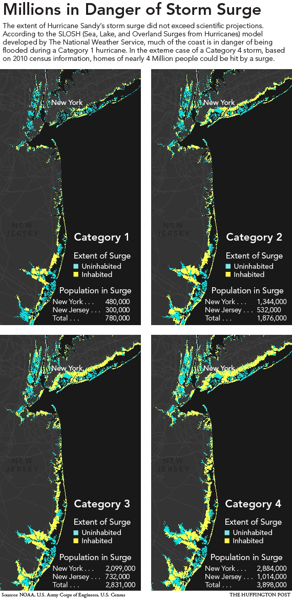
From the Huffington Post:
Given the size and power of the storm, much of the damage from the surge was inevitable. But perhaps not all. Some of the damage along low-lying coastal areas was the result of years of poor land-use decisions and the more immediate neglect of emergency preparations as Sandy gathered force, according to experts and a review of government data and independent studies.
Authorities in New York and New Jersey simply allowed heavy development of at-risk coastal areas to continue largely unabated in recent decades, even as the potential for a massive storm surge in the region became increasingly clear.
In the end, a pell-mell, decades-long rush to throw up housing and businesses along fragile and vulnerable coastlines trumped commonsense concerns about the wisdom of placing hundreds of thousands of closely huddled people in the path of potential cataclysms.
And of course we have the real estate industry's damage control piece in the NY Times:
Mr. Romski said that a heavy-duty, sophisticated drainage system, designed to handle flood surges, was instrumental in mitigating flooding. The system — which features underground chambers, wide street mains and storm drains on each house property — connects to large sewer mains that the developer installed in public streets that they rebuilt around the project site, as part of an agreement with the city, Mr. Romski said. Also helpful was a natural buffer of sand and beach grass that was maintained near the boardwalk. It also helped that much of the boardwalk in front of the project stayed intact to break the roaring surf, unlike the long stretch west of 88th Street that was obliterated.
So what he is actually saying is that they were just lucky that the boardwalk stayed intact in that section and bore the brunt of the surge. They may not be so lucky next time.
And the Daily News:
Rosemary Scanlon, dean of New York University’s Schack Institute of Real Estate, said the market will rebound.
“The fears were widespread that people would move out of New York” after 9/11, she said. “It didn’t happen.”
But buildings — especially in Zone A — will need to be constructed differently, she said. Boilers and electrical equipment may need to be moved to higher floors, generators may become standard and towers may now be built further from the shore.
“Building on the waterfront was considered to be a great idea until the storm came,” she said.
Daniel Kessler, spokesman for 350.org, a climate change awareness group, said with rising global temperatures and sea levels, building in flood-prone areas isn’t a “very smart thing to do.”
Actually, building on the waterfront was always considered risky. We were warned. We didn't listen. Zone B areas flooded as well as Zone A. Wake up, people.
Subscribe to:
Posts (Atom)


