Showing posts with label sea level. Show all posts

Friday, September 29, 2023

Breaking Ground


 NY Post

As New York City sinks under the mass of its own weight, some hotspots are sinking faster than others, including LaGuardia Airport, Arthur Ashe Stadium and Coney Island, according to a new NASA report.

Researchers with NASA’s Jet Propulsion Laboratory and Rutgers University identified several key locations within the five boroughs that are sinking faster than the average 1.6 millimeters per year experienced by the rest of New York City.

LaGuardia’s runways and Arthur Ashe Stadium – home of the US Open – both saw the most rapid sinking from 2016 to 2023, falling at 3.7 and 4.6 millimeters per year, respectively, researchers published Wednesday in Science Advances.

Scientists warned that while the city’s sinking might seem slow, the addition of rising sea levels could prove disastrous during powerful storms like Sandy. 

“Protecting coastal populations and assets from coastal flooding is an ongoing challenge for New York City,” the researchers wrote. “The combined effect of natural sea level variations and destructive storms is being increasingly exacerbated by ongoing sea level rise.”

Along with LaGuardia and Arthur Ashe, the study found that Interstate 78, which passes through the Holland Tunnel that connects Manhattan to New Jersey, was also sinking at nearly double the rate of the rest of the city.

The same was true for Highway 440, which connects Staten Island to the Garden State.

Other areas sinking faster include Coney Island, the southern half of Governors Island, Midland and South Beach in Staten Island, and Arverne by the Sea, a coastal neighborhood in southern Queens.
Tuesday, January 28, 2020

Comptroller Stringer rejects federal seawall plan for city


http://theforumnewsgroup.com/wp-content/uploads/2020/01/StringerStormBarrier1.jpg

The Forum

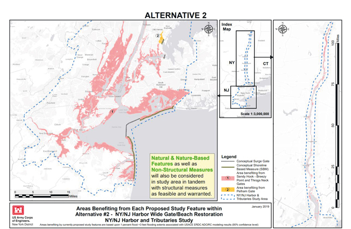
 City Comptroller Scott Stringer on Friday fired off a four-page letter to the U.S. Army Corps of Engineers condemning their plan to construct offshore storm surge barriers in New York Harbor.

In the letter, Stringer castigated the corps’ proposal for not adequately protecting coastal communities from the threat of sea level rise and associated flooding. The Comptroller’s letter also highlighted the long construction timeline associated with the storm barriers and their high cost estimate — noting that the largest of the options outlined in the proposal would take a quarter of a century to build out, cost six times that of shorefront resiliency options, and endanger the delicate ecosystem of the harbor including the region’s network of marshes and wetlands that are critical to mitigating storm surge.

Stringer said he is calling on the agency to implement an integrated and environmentally-conscious approach that’s focused on onshore resiliency measures including localized floodwalls, dune and wetland restoration, living shorelines, reefs, and levees. Stringer’s missive noted that this approach was the only way to protect the city from rising sea levels, storm surge from non-catastrophic weather events, and increasingly catastrophic storms in the future.
 

The letter follows a May 2019 report published by the comptroller, “The Costs of Climate Change: New York City’s Economic Exposure to Rising Seas,” which exposed substantial underspending of federally-appropriated Superstorm Sandy recovery funding that the City had not yet allocated to protect vulnerable coastline communities including only 57 percent of a combined $14.5 billion in federal funds. The report concluded that lagging spending posed a threat to the 520 miles of coastline citywide, which is estimated at a combined property value of $101.5 billion within the city’s current 100-year floodplain map — marking a more than 50 percent increase in value since 2010.

“There’s no question about it — a future Superstorm Sandy will come and New York Harbor will bear the brunt of it. Too many of our waterfront communities are all too vulnerable to the next storm, or even the next high tide,” Stringer said Friday. “I am urging the Army Corps of Engineers to get shovels in the ground on shorefront resiliency options like floodwalls, dune systems, wetlands, and levees that can protect New Yorkers and their livelihoods. Lives are at stake, homes and businesses are on the line, and futures hang in the balance. We need to act with urgency, plan strategically, and build out resiliency efficiently in the era of climate change, because time is not on our side.”

Monday, June 5, 2017

Sea level rise response in Staten Island vs Queens

There's a great photoessay on Curbed about the difference in waterfront development in Staten Island vs. Queens. Staten Island is returning to nature while in Queens the attitude is build, build, build!

We live in a strange moment, when on the one hand, the state government is paying millions of dollars to help hundreds of residents move away from the water in an orderly fashion, but on the other hand, the city and private developers are encouraging thousands of new residents to move into rapidly constructed waterfront towers that cost billions of dollars. These diametrically opposed plans for the waterfront are creating very different versions of the future, even as the city has begun to initiate its own managed retreat programs in Edgemere and beyond.

Sunday, April 16, 2017

Edgemere's vision for its future

From Curbed:

As sea levels continue to rise, difficult choices are facing Edgemere and many other communities around New York City, and the outcomes of the strategies used here will only become more relevant in the years to come.

The Resilient Edgemere plan presents a variety of short- and long-term projects for the neighborhood, comprising zoning changes, new residential development, and transportation improvements. Some of the highlights include a $14 million investment into creating an elevated berm along the neighborhood’s unprotected coastline, a $68 million investment into NYCHA’s Beach 41st Street Houses, and the elevation of 41 attached homes above flood risk levels.

The most striking physical changes proposed in the plan are a new rocky shoreline that could replace the existing salt marsh habitat along the coast of Jamaica Bay, and the numerous illustrations showing that the northernmost part of Edgemere’s residential community, on Beach 43rd Street above Norton Avenue, would be replaced by open space and a new park. “As a proposal of de-densifying the area above Norton Avenue, the short-term tool there would be to change the zoning so that new construction of housing would not be possible,” explains Morris. “Over the long term, this area would transition from a housing area to a less-housed area. What that means is maintaining the balance of the population of the community and moving it to a safer space.”

Thursday, October 27, 2016

Students help the ecosystem of Jamaica Bay


From CBS 2:

It’s a new day for Jamaica Bay. Hundreds of volunteers will spend a week digging in to help shore up the coastline.

As CBS2’s Vanessa Murdock reported, their efforts may make the area more storm-resistant and keep local wildlife thriving.

Over one week, 400 volunteers will shovel the shoreline of the Jamaica Bay Wildlife Refuge to make room for 10,000 native trees and shrubs. They’re plant now to create a more resilient coast in the future.

“Our world is changing, sea level is rising. We’re having increased flooding in areas that were drier than before.” Chief of Resource Stewardship, Gateway National Recreation Area, Patti Rafferty said, “Sandy produced a surge of nearly 8.5-ft in Jamaica Bay – caused big problems for the ecosystem.”

Rafferty said the beach was breached. What was a freshwater source for hundreds of species of birds became brackish. Trees were uprooted, plants died, and invasive species took over.

Now, volunteers – led by the National Park Service, Jamaica Bay Rockaway Parks Conservancy, and the Nature Conservancy are taking it back.

They’re making room for natives like juniper and pitch pine.

Saturday, February 27, 2016

Boats will be needed more than streetcars

From DNA Info:

A 20-foot rise in sea level would submerge large tracts of land in all five New York City boroughs. A 20-foot rise in sea level would submerge large tracts of land in all five New York City boroughs.

While New Yorkers worry about the ways in which residential and commercial developments, and streetcars, will affect the city's waterfront in the short term, they have rising sea levels to obsess about over the next few decades.

Oceans around the globe will rise as much as 4.3 feet by 2100, at a rate faster than they have in the past 2,800 years, according to two different studies published Monday in the journal Proceedings of the National Academy of Sciences. The researchers attribute the increase in sea levels to rising temperatures driven by the burning of fossil fuels, which most scientist agree emits heat-trapping gases.

One study, led by Rutgers earth and planetary sciences professor Robert Kopp, estimated that sea levels will rise 22 to 52 inches by 2100 if they continue at their current rate. A second study, overseen by the Potsdam Institute for Climate Impact Research in Germany, arrived at a similar conclusion: sea levels will climb three to four feet. (Until the world industrialized in the 1880s, oceans rose no more than 1 to 1.5 inches a century, and they would cycle between rising and falling.)

Those estimates aren't quite as extreme as one published last summer by Science Magazine, which examined the impact that 2 degrees of global warming would have on coastlines worldwide. The planet's warming was predicted to raise sea levels by at least 20 feet as early as 2200. Its effect on New York City shores can be seen in a map below, map built by the group Climate Control.

Thursday, July 16, 2015

Climate change = buh-bye LIC

From Curbed:

New data published in Science shows that if the planet warms by 2 degrees Celsius, sea levels will rise about 20 feet. It's pretty much a given that this will happen, it's just a matter of when—it could be by the end of the century. A 20-foot rise is no where near Linn's extreme depiction of a 100-foot rise, but it would still radically alter our coastline. The group Climate Central created an interactive map (h/t Gizmodo) that shows what this would mean for major cities in the United States. In New York, it means that entire neighborhoods would be wiped out and 1.8 million people would be displaced.

It's gonna be like this year round!

Wednesday, August 28, 2013

Storms will bury NYC under water by the end of the century

From the Daily News:

Based on projections from the National Weather Service and the U.S. Army Corps of Engineers, if a storm equivalent in strength to Hurricane Sandy were to hit the five boroughs in the year 2100, vastly larger swaths of the city would be submerged.

The reason is simple. Sea levels are forecast to rise by as much as six feet before the end of the century, making low lying cities like New York all but defenseless to the wrath of powerful storms.

Unfortunately, over the past decade, scientific projections on sea level rise have grown rapidly as more data on climate change has continued to be analyzed.

Six years ago. the Intergovernmental Panel on Climate Change (IPCC) estimate that by 2100 sea level would rise by a maximum of 23 inches. In a draft of this year’s report, the final version of which is to be released this fall, the IPCC revised that outlook to a maximum of six feet.


But not to fear! The City has opened a water-resistant park at the edge of LIC, which is the only neighborhood in Queens that matters anymore.

From Curbed:

In a post-Sandy city, the first question that comes to mind with new waterfront developments is "how did it fare during the storm?" Hunters Point South, it turns out, fared very well. "We were surprised at how well the water drained," said Manfredi. "We always anticipated that there would be a major storm." Every part of the park is design to take on water. After Hurricane Sandy, all of the major surfaces were undamaged and intact, and most of the trees survived because all grades in the park were calibrated to accommodate storms, so the tree roots were protected.

No mention of the contaminated river and creek water that bathed Hunters Point.

Oh, and the trees survived because they weren't there yet. In fact, none of it was there on October 31, 2012. The satellite imagery proves it.

We'll see how well this area fares after the next 100 year storm, which, according to past experience, should be happening any day now...

Monday, December 10, 2012

Storm problems were predicted decades ago


From the AP:

More than three decades before Superstorm Sandy, a state law and a series of legislative reports began warning New York politicians to prepare for a storm of historic proportions, spelling out scenarios eerily similar to what actually happened: a towering storm surge; overwhelming flooding; swamped subway lines; widespread power outages. The Rockaway peninsula was deemed among the "most at risk."

But most of the warnings and a requirement in a 1978 law to create a regularly updated plan for the restoration of "vital services" after a storm went mostly unheeded, either because of tight budgets or the lack of political will to prepare for a hypothetical storm that may never hit.

Some of the thorniest problems after Sandy, including a gasoline shortage, the lack of temporary housing and the flooding of commuter tunnels, ended up being dealt with largely on the fly.

"I don't know that anyone believed," acknowledged Gov. Andrew Cuomo this past week. "We had never seen a storm like this. So it is very hard to anticipate something that you have never experienced."

Asked how well prepared state officials were for Sandy, Cuomo said, "not well enough."
It wasn't as if the legislative actions over the years were subtle. They all had a common, emphatic theme: Act immediately before it's too late.

The 1978 executive law required a standing state Disaster Preparedness Commission to meet at least twice a year to create and update disaster plans. It mandated the state to address temporary housing needs after a disaster, create a detailed plan to restore services, maintain sewage treatment, prevent fires, assure generators "sufficient to supply" nursing homes and other health facilities, and "protect and assure uninterrupted delivery of services, medicines, water, food, energy and fuel."

Reports in 2005, 2006 and 2010 added urgency. "It's not a question of whether a strong hurricane will hit New York City," the 2006 Assembly report warned. "It's just a question of when."

A 2010 task force report to the Legislature concluded: "The combination of rising sea level, continuing climate change, and more development in high-risk areas has raised the level of New York's vulnerability to coast storms. ... The challenge is real, and sea level rise will progress regardless of New York's response."

The Disaster Preparedness Commission met biannually some years, but there are gaps in which there is no record of a meeting. However, some administrations, including Cuomo's, convened many of the same agency heads to discuss emergency management. But even under Cuomo, who has taken a much greater interest in emergency management after three violent storms in his first two years in office, there are still three vacancies on the commission.

Friday, November 23, 2012

IBO criticizes waterfront development


From the NYC Independent Budget Office's Web Blog:

The Mayor’s March 2011 report Vision 2020: New York City Comprehensive Waterfront Plan forecast the coming of storms like Sandy and the potential affects: “The rise in sea level and increased frequency and magnitude of coastal storms will likely cause more frequent coastal flooding and inundation of coastal wetlands as well as erosion of beaches, dunes, and bluffs.” A few weeks later, in an update to PlaNYC, the warnings were reinforced: “As a city with 520 miles of coastline—the most of any city in America—the potential for more frequent and intense coastal storms with increased impacts due to a rise in sea level is a serious threat to New York City.”

Yet even as City Hall grappled with these concerns it continued to put substantial resources into major development projects on the waterfront, rezoning sites as manufacturing declined— including some in prime areas for flooding, the so-called Zone A evacuation areas. Just one month before Sandy struck the city, Mayor Bloomberg announced a plan by private developers to build a $500 million complex on city-owned land on Staten Island’s North Shore that would include the world’s largest Ferris wheel as well as a hotel and outlet mall. Part of the site sits in a floodplain.

An even larger development project is planned on the Coney Island waterfront, one of the neighborhoods hardest hit by Sandy. The city has rezoned the area to allow the development of hotels, housing, and a new amusement park, and has allocated more than $400 million for sewer upgrades, land acquisition, lighting, boardwalk and park improvements, and other projects to foster the redevelopment plan. On the Queens waterfront, the city is investing $147 million in the Hunters Point South project, which also sits in Zone A. Already under construction, Hunters Point South includes 5,000 apartments, a 1,100-seat school, and retail space.


Photo from LiQCity

Tuesday, November 20, 2012

Rethinking rebuilding


From NBC News:

Federal projects intended to help protect New York and New Jersey towns from hurricanes and coastal flooding have languished – many unfunded -- for decades, the I-Team has learned.

The stalled projects, often approved by Congress as far back as the 1980s and 90s, were intended to study the feasibility of manmade barriers like seawalls, marshlands or large sand dunes to protect coastal areas on Staten Island as well as the Rockaways, Long Island and the Jersey shore.

One such study, aimed at making recommendations for flood barriers along the south shore of Staten Island, remains unfinished even though it was commissioned in 1993.

The south shore of Staten Island was the scene of some of the worst damage caused by Sandy.

"This system is broken. It needs to be fixed. It needs to be overhauled,” said U.S. Rep. Michael Grimm. “Something gets approved and then it gets lost. It's almost like putting it in a bottomless pit and it never gets done."


From The Indypendent:

Sandy has triggered a public debate about how to protect the city in the future given the growing consensus that powerful storms and sea level rise are inevitable. But who will be protected? And who will pay?

Gov. Andrew Cuomo thinks New York City needs floodgates. Mayor Michael Bloomberg thinks other drastic measures have to be taken. Both of them have joined the chorus linking Sandy’s devastation with global climate change. But neither of them has suggested he would stray from government’s long tradition of protecting big real estate interests and abandoning those living at the margins, such as the tenants in the public housing projects of the Rockaways, Coney Island and Red Hook.

There needs to be a more equitable strategy going forward that forces the powerful real estate giants in Manhattan to pay the steep price of fortifying their luxury enclaves and puts public funds into protecting the most vulnerable working people.

The Cuomo and Bloomberg proposals are examples of short-term thinking dressed up in green rhetoric. They fail to look deeply at the long-term sustainability of the city. They obscure the basic questions of who benefits and who pays. If the chief beneficiaries of expensive dikes and other greening measures are downtown and waterfront property owners, why shouldn’t they foot their fair share of the bill? If the captains of the growth machine took the risk with their capital, why should government have to bail them out?

On the other hand, if the city and state administrations seriously want to address climate change, they might begin to limit development in flood-prone areas instead of promoting it. They could also put more money into preserving and retrofitting the city’s housing stock, especially public housing and homes in vulnerable areas, instead of wasting money to protect lavish new developments.


From the NY Times:

Across the nation, tens of billions of tax dollars have been spent on subsidizing coastal reconstruction in the aftermath of storms, usually with little consideration of whether it actually makes sense to keep rebuilding in disaster-prone areas. If history is any guide, a large fraction of the federal money allotted to New York, New Jersey and other states recovering from Hurricane Sandy — an amount that could exceed $30 billion — will be used the same way.

Tax money will go toward putting things back as they were, essentially duplicating the vulnerability that existed before the hurricane.


From the Huffington Post:

Given the size and power of the storm, much of the damage from the surge was inevitable. But perhaps not all. Some of the damage along low-lying coastal areas was the result of years of poor land-use decisions and the more immediate neglect of emergency preparations as Sandy gathered force, according to experts and a review of government data and independent studies.

Authorities in New York and New Jersey simply allowed heavy development of at-risk coastal areas to continue largely unabated in recent decades, even as the potential for a massive storm surge in the region became increasingly clear.

In the end, a pell-mell, decades-long rush to throw up housing and businesses along fragile and vulnerable coastlines trumped commonsense concerns about the wisdom of placing hundreds of thousands of closely huddled people in the path of potential cataclysms.


And of course we have the real estate industry's damage control piece in the NY Times:

Mr. Romski said that a heavy-duty, sophisticated drainage system, designed to handle flood surges, was instrumental in mitigating flooding. The system — which features underground chambers, wide street mains and storm drains on each house property — connects to large sewer mains that the developer installed in public streets that they rebuilt around the project site, as part of an agreement with the city, Mr. Romski said. Also helpful was a natural buffer of sand and beach grass that was maintained near the boardwalk. It also helped that much of the boardwalk in front of the project stayed intact to break the roaring surf, unlike the long stretch west of 88th Street that was obliterated.

So what he is actually saying is that they were just lucky that the boardwalk stayed intact in that section and bore the brunt of the surge. They may not be so lucky next time.

And the Daily News:

Rosemary Scanlon, dean of New York University’s Schack Institute of Real Estate, said the market will rebound.

“The fears were widespread that people would move out of New York” after 9/11, she said. “It didn’t happen.”

But buildings — especially in Zone A — will need to be constructed differently, she said. Boilers and electrical equipment may need to be moved to higher floors, generators may become standard and towers may now be built further from the shore.

“Building on the waterfront was considered to be a great idea until the storm came,” she said.

Daniel Kessler, spokesman for 350.org, a climate change awareness group, said with rising global temperatures and sea levels, building in flood-prone areas isn’t a “very smart thing to do.”


Actually, building on the waterfront was always considered risky. We were warned. We didn't listen. Zone B areas flooded as well as Zone A. Wake up, people.

Thursday, November 8, 2012

Are sea barriers the way to go?

From the NY Times:

The technology of movable sea barriers, from Stamford’s modest flap gate to London’s mighty 10-gate system in the River Thames, has long intrigued engineers and planners contemplating a solution for low-lying areas of New York City. The notion is that such a system could one day block surges from Long Island Sound and the Atlantic Ocean into the East River and New York Harbor.

Now, in the aftermath of the devastating storm, one question is front and center: Should New York armor itself with steel and concrete at a cost of billions of dollars?

Experts whose barrier designs and studies from a conference in 2009 were issued on Monday in book form argue that anything short of sea gates would be a “Band-Aid” approach.

Mayor Michael R. Bloomberg has expressed wariness about the barrier proposal, saying he is not sure the gates would work well enough. Yet, it is clear that his administration’s view is evolving.

Saturday, November 3, 2012

Not the brightest idea


"The attached photo was taken yesterday. This is in Staten Island in an "A" evacauation zone, and a 9.5 acre tidal wetland. Approximately 90 two-family homes are proposed for this site! BTW, radium from the Manhattan Project is stored across the street... and local schools are operating at 150% of capacity... but hey, it's waterfront! Money will be made, for sure." - anonymous

Thursday, November 1, 2012

The same old song and dance

From the NY Observer:

We already know Mayor Bloomberg favors waterfront development, come hell or high water—literally—and so, too, does his former development czar Dan Doctoroff, now head of Bloomberg LP.

It was Mr. Doctoroff, in his capacity as deputy mayor for economic development, who thought up many of the schemes that have led to new apartment towers on the waterfront in Williamsburg and Hunters Point. Thousands of units have been built, tens of thousands have been planned. Mr. Doctoroff still believes that is a good idea, so long as appropriate measures are taken.

“I am obviously a believer in waterfront development,” Mr. Doctoroff said, “but development that is buttressed by strong building codes and is done in conjunction with a smart adaptability strategy. That was a major reason why we made adaptation to climate change a pillar of PlaNYC.”

Not that there is any kind of causation here, but in spite of PlaNYC, the city still got clobbered yesterday.


Also from the Observer:

The infrastructure needed to protect waterfront developments can be considerable, drawing important resources away from other areas.

Mayor Bloomberg did not appear prepared to undertake such investment. “We cannot build a big barrier reef off the shore to stop the waves from coming in; we can’t build big bulkheads that cut people off from the water,” the mayor said. “Robert Moses actually did that with the roads, and we’ve been ever since spending a fortune trying to get around it.”

The consensus among planners The Observer spoke with on Monday and Tuesday is that more needs to be done.

Saturday, August 25, 2012

Keeping our heads above water

From the Daily News:

The City Council voted Wednesday to order a city panel of climate scientists to come up with plans to deal with rising sea levels and extreme heat that could result from climate change.

The idea is to figure out ways to deal with — or ideally prevent — the kind of massive flooding that could leave chunks of a city of islands underwater during storms.

City officials — who say the sea level could rise by about 4 1/2 feet by the end of the century — have already begun to plan development projects with rising sea levels in mind.

The massive Willets Point development in Queens is being built at an elevated level to keep new buildings out of the floodplain, as is the new Sims Recycling Facility in Brooklyn.

Brooklyn Bridge Park and Governors Island were designed with higher shorelines and salt-resistant plants that can withstand occasional flooding, and flood gates were installed at the Tallman Island Wastewater Treatment Plant.

The city has also tweaked its zoning code to allow building owners to store electrical equipment on the roof, instead of in flood-prone basements.

Friday, July 29, 2011

City praised for flooding response?

From Crains:

Facing the threat of water-related disruptions from climate change, the Bloomberg administration has prepared better than other city governments around the country, according to a report released Tuesday.

The report by the Natural Resources Defense Council, an environmental nonprofit, examines 12 cities around the U.S. It found that the cities will face rising seas levels, increased flooding and more frequent and intense storms.

The report also predicted increases in annual precipitation, saltwater intrusion in drinking water, erosion, and strains on the water supply.

But the report found that New York was one of the best prepared cities in the group. Praising the efforts of the city's Department of Environmental Protection's climate change task force, as well as the Department of City Planning's Vision 2020 waterfront plan, the Natural Resources Defense Council found that New York was among the most proactive.


I guess NRDC hasn't been around after a heavy rain.

Sunday, January 9, 2011

Bloomberg: Let 'em drown, just don't stop development!

From DNA Info:

The state just released a long-anticipated report on how to combat rising sea levels — New York Harbor is expected to rise 2 to 5 inches within the next 20 years — but the city isn't on board.

Adam Freed, deputy director of the Mayor's Office of Long-Term Planning and Sustainability, is worried that the state's recommendations will restrict development in the city, which could hurt the region's economy.

The state Sea Level Rise Task Force wants to add extra regulatory hurdles for development projects in potential flood zones and encourage local governments to move critical infrastructure elsewhere.

Those proposals and others the state is recommending "have the potential to add substantial costs and time to development projects and infrastructure investments," Freed said in a Dec. 14 letter to the state Department of Environmental Conservation, which is spearheading the sea level plan.

"Implementing these measures without a thorough understanding of the cost and time implications or the scope of their reach is premature," Freed added.

Two weeks after receiving Freed's comments on the draft report, the state released a final version Dec. 31 that still includes the measures Freed opposed.

A spokeswoman for the Department of Environmental Conservation said other members of the Sea Level Rise Task Force thought the new regulations were important, so the state did not want to remove them.

The Sea Level Rise Task Force's report is just a recommendation, and Gov. Andrew Cuomo would have to take action to implement it.

Cuomo's office did not immediately respond to a request for comment.

The report, which is several years in the making, covers New York State as a whole, but it also mentions New York City as one of the most at-risk areas for flooding.

The sea level in New York Harbor has risen over 15 inches in the past 150 years and is expected to rise another 2 to 5 inches within the next 20 years, according to the report.

More than 215,000 New York City residents live in an area that has a 1 percent chance of flooding each year, according to federal standards.

Tuesday, September 15, 2009

Should we protect ourselves against storm surges?

From the Wall Street Journal:

Scientists are laboring to make their predictions more reliable. While they do, New York has become an urban experiment in the ways that seaboard cities can adapt to climate change over the next century. For their part, the city's long-term planners are taking action but are trying to balance the cost of re-engineering the largest city in the U.S. against the uncertainties of climate forecasts.

"We can't make multibillion-dollar decisions based on the hypothetical," says Rohit Aggarwala, the city's director of long-term planning and sustainability.

Still, prompted by a possibility of floods from higher seas, some university-based marine researchers and civil engineers are debating whether New York ought to protect its low-lying financial district, port, power grid and subways with storm surge barriers like the mobile bulwarks that safeguard London, Rotterdam, Netherlands, and St. Petersburg, Russia. Engineering concepts for multibillion-dollar barriers around New York harbor were discussed here this week during the H209 Water Forum, an international conference on coastal cities and climate change, held by the Henry Hudson 400 Foundation at the Liberty Science Center.

Sunday, February 22, 2009

Building on the shore: not the wisest move

NEW YORK (AP) -- Water levels around New York City could rise by 2 feet or more in the coming decades and average temperatures will likely go up at least 4 degrees.

That's according to a report released Tuesday by a panel of scientists convened by Mayor Michael Bloomberg.

The report by the New York City Panel on Climate Change says the city must adapt to global warming or risk having to rebuild facilities after flooding.

Bloomberg and panel members released the report at a wastewater treatment plant on the Rockaway peninsula. The facility is preparing for climate change by raising equipment higher off the ground.

According to the report, New York City can expect more storms, more days with the temperature over 90 degrees and fewer sub-freezing days over the next century.


And from Newsday:

...a New York State task force that is readying recommendations on the best way to adapt to sea level rise soldiers on. That work comes as a federal report released last month by the Environmental Protection Agency said coastal regions "need to rigorously assess vulnerability" to sea level rise and plan strategies to protect property, wetlands and barrier islands.

Among the advice the task force could deliver: direct development away from coastal areas; elevate roads and other infrastructure; or change wetlands regulations to increase no-development zones so marshes threatened by sea level rise have room to migrate upland.


You mean building along the waterfront might not be the best idea? So all the building at Willets Point, in LIC and Rockaway may actually do more harm than good? Wow.